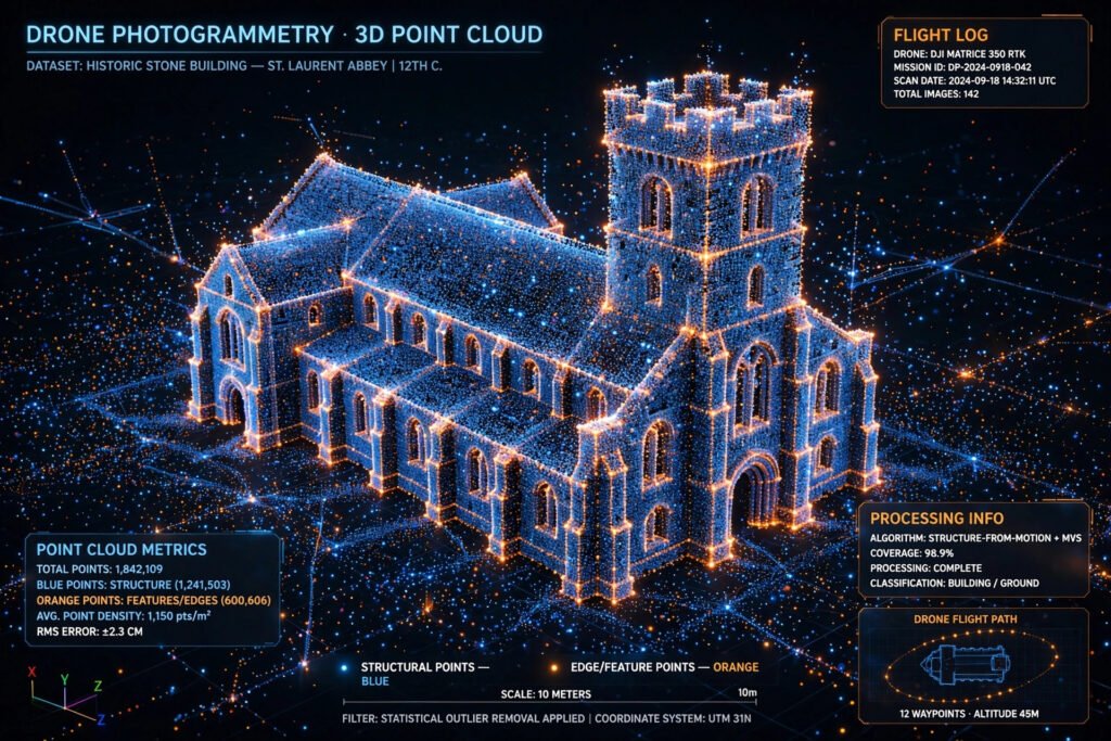
Every bridge, building, and stretch of road can now be copied into a digital replica made of millions of tiny dots. That capability comes from two technologies that increasingly work side by side: photogrammetry and point cloud processing. If you have ever asked what is photogrammetry, understanding point cloud technology and 3D mapping is the real key to the answer. This guide explains what is photogrammetry, how point clouds turn photographs and laser scans into measurable three-dimensional worlds, and why industries from construction to archaeology now treat these tools as essential.
At its core, the idea is surprisingly simple. Cameras and scanners capture the real world, software finds the geometry hiding inside that data, and the result is a three-dimensional map you can measure, explore, and build from. Understanding point cloud technology and 3D mapping begins with two definitions, and everything else in this article builds on them: photographs give you the picture, and point clouds give you the geometry.
Key Takeaways
- Photogrammetry is a measurement technique that extracts 3D shapes, sizes, and positions from overlapping photographs taken at different angles.
- A point cloud is a set of thousands or millions of individual points, each with X, Y, and Z coordinates and often color or intensity data, that together form a digital replica of a real object or place.
- Photogrammetry builds point clouds from photos through a process called structure from motion, while LiDAR builds them from laser pulses.
- Typical outputs include textured 3D models, orthomosaics (stitched, map-accurate aerial images), and digital elevation models.
- Photogrammetry is cheaper and captures full color and texture, while LiDAR is more precise, works in darkness, and sees through vegetation.
What Is Photogrammetry?
Photogrammetry is a technique that uses photographs to obtain reliable measurements and three-dimensional information about physical objects and environments. Multiple images are captured from different angles with generous overlap. Software analyzes common features across the photos, determines where each camera was positioned, and reconstructs the scene in 3D, producing textured models, maps, measurements, or point clouds.
One reason photogrammetry has spread so quickly is accessible hardware. It works with professional cameras, drones, and even smartphones, so teams do not always need expensive scanners. Result quality depends on image resolution, camera position, lighting, image overlap, and the processing software.
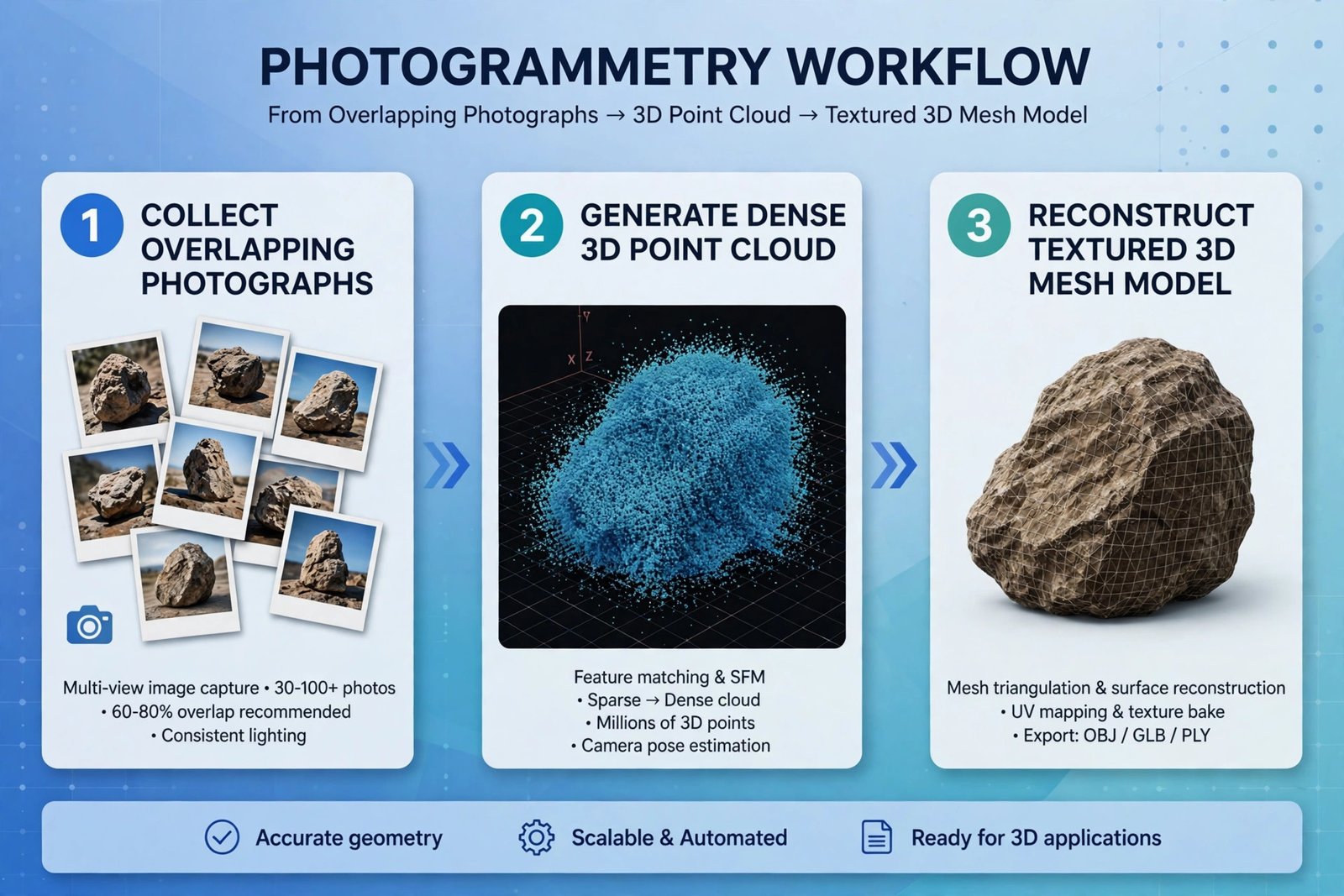
The engine behind most modern photogrammetry is called structure from motion, or SfM. These computer vision algorithms match the same features across many images, then calculate each camera location and the 3D positions of the matched points. A sparse point cloud is reconstructed first, then densified into a detailed cloud or mesh, which can be refined further in 3D modeling software like the tools compared in our AutoCAD vs SolidWorks guide. Understanding what is photogrammetry, with point cloud technology and 3D mapping explained at this level, makes the workflow easy to follow.
What Is a Point Cloud and How Does Point Cloud Technology Work?
A point cloud is a collection of individual points representing the shape and position of objects in three-dimensional space. Each point stores its X, Y, and Z coordinates, plus color, intensity, or other attributes depending on the scanner. Millions of points together create a highly detailed digital representation of a building, road, landscape, or entire environment.
Point clouds are commonly generated by LiDAR scanners, laser scanners, depth cameras, and photogrammetry software. A surveyor, for example, can scan a construction site to capture walls, floors, structural elements, and terrain in one dataset. That data is imported into specialized software for measurement, analysis, and conversion into 3D models.
What makes point clouds so useful is that they describe the world as it actually is. Instead of manually measuring every wall or slope, professionals work with a direct digital capture. Distances, elevations, and slopes are extracted from the same dataset, and capture is far faster than manual measurement.
How Does Photogrammetry Actually Create 3D Models?
The photogrammetry workflow starts with image collection and ends with usable 3D data. The camera captures many photographs from different positions with substantial overlap, the software identifies matching features and camera relationships, and the subject is rebuilt in three dimensions. Here is the process most professionals follow:
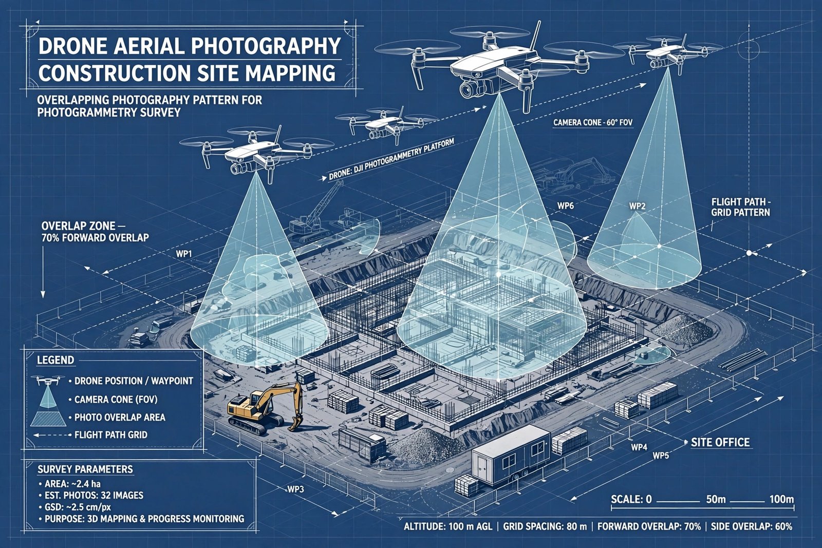
- Plan the capture. Decide the area to cover, the flight path or camera positions, and the desired detail level. Aerial surveys typically aim for around 70 to 80 percent forward overlap between images so the software has plenty of shared features to match.
- Collect the images. Capture the photographs with consistent lighting and sharp focus. Drones handle large sites efficiently, while ground cameras suit smaller objects and interiors.
- Upload and align. The software detects distinctive features in each image and finds the same features across overlapping photos.
- Build a sparse point cloud. Using a calculation called bundle adjustment, the software solves for the position and orientation of every camera and the 3D coordinates of the matched points.
- Densify the cloud. Multi-view stereo algorithms expand the sparse points into a dense point cloud containing millions of points.
- Generate the outputs. The dense cloud can be meshed into a 3D model, textured with the original photographs, or converted into an orthomosaic, a digital elevation model, or a colored point cloud.
- Geo-reference the result. Ground control points with known coordinates, or GPS and RTK/PPK positioning data from the drone, place the model accurately on the real-world map.
Accuracy improves dramatically with good ground control. With ground control points or RTK-corrected positioning, photogrammetry can reach centimeter-level accuracy; without them, results may be off by decimeters. Professional survey projects therefore pair careful image capture with survey-grade control.
What Are the Benefits of 3D Mapping?
Understanding what is photogrammetry also means understanding the benefits of 3D mapping that made the technology so popular. The biggest win is accessibility: meaningful 3D data can often be captured with equipment far cheaper than advanced laser scanners. A second major benefit is speed, since hundreds of photographs of a large site can be captured in a single session and processed into spatial data afterward.
- Lower cost of entry. A camera or a consumer drone can start a photogrammetry project, putting 3D mapping within reach of small firms and even individuals.
- Photorealistic results. Because the source data is photographs, the resulting models carry real color and texture, which is invaluable for inspection, documentation, and client presentations.
- Safer data collection. Drones can photograph roofs, towers, cliffs, and other hard-to-reach areas without putting people in dangerous positions.
- Repeatable documentation. Sites can be captured at different stages, letting teams compare progress against plans over time.
- Better collaboration. A shared 3D dataset lets teams in different locations review the same conditions without traveling to the site.
These benefits moved point cloud technology and 3D mapping from research labs into everyday commercial work. A drone pilot can now capture in an afternoon what a survey crew once measured over days, and the office gets a richer dataset.
Photogrammetry vs LiDAR: Which 3D Mapping Method Is Better?
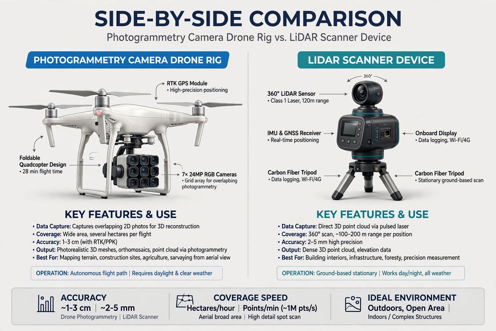
The honest answer is that neither method wins in every situation; they solve different problems. LiDAR is an active technology that fires laser pulses and measures their return time, while photogrammetry is passive and relies on visible light in photographs. That single difference drives most of the trade-offs in the comparison table below.
| Feature | Photogrammetry | LiDAR |
|---|---|---|
| How it senses | Passive, uses photographs and ambient light | Active, fires laser pulses and times their return |
| Typical accuracy | Centimeter level with ground control or RTK, looser without it | Typically 1 to 5 cm, even in difficult conditions |
| Color and texture | Full RGB, photorealistic output built in | No native color, intensity values only, color needs a separate camera |
| Vegetation | Captures only visible surfaces, cannot see through canopy | Laser pulses penetrate vegetation to reach the ground |
| Lighting needs | Needs consistent daylight, struggles in darkness | Works in darkness and poor light |
| Equipment cost | Low to moderate, drones and cameras are widely affordable | High to very high, often tens to hundreds of thousands of dollars |
| Processing time | Hours to days for dense reconstruction | Minutes to hours for scan registration |
| Ease of learning | Moderate, many accessible tools and tutorials | Higher, needs sensor calibration and registration skill |
| Best for | Visual models, open well-lit sites, budget-sensitive projects | Precision surveys, forests, low-light or complex terrain |
In practice, the two are often combined. A project might use laser scanning for structural measurements and drone photogrammetry for outdoor areas, then align both datasets. This hybrid approach gives LiDAR-grade geometry plus photogrammetry-grade visuals, which is exactly what digital twin and building information modeling projects need.
Where Are Photogrammetry and Point Clouds Used Today?
Point cloud technology and 3D mapping now support work across a long list of industries. Anywhere the shape of the real world matters, someone is probably capturing it as a point cloud. These are the most established applications:
- Surveying and mapping. Terrain, roads, and buildings are captured faster than with manual methods, and distances and elevations are extracted from the data.
- Construction. Sites are documented at each stage so teams can compare actual conditions with plans and catch discrepancies early.
- Architecture and engineering. Existing structures are captured for renovation and inspection based on real conditions, not old drawings.
- Mining. Open pits and stockpiles are measured repeatedly to calculate volumes and monitor change.
- Agriculture and land management. Fields and terrain are mapped to support planning and drainage analysis.
- Archaeology and cultural heritage. Historic sites are preserved as detailed 3D records that can be studied without touching the originals.
- Forestry. LiDAR point clouds measure canopy structure and the terrain beneath trees where photogrammetry cannot reach.
What Does the Future of 3D Mapping Look Like?
The future of 3D data capture is more accessible, more automated, and more unified. Cameras, scanners, drones, and processing software keep improving, while artificial intelligence makes it easier to extract useful information from enormous datasets, a pattern we also explore in our guide to AI fitness wearable data architecture. Future workflows will likely combine photographs, laser scans, and satellite data into unified digital environments, letting distributed teams review the same accurate data without always visiting the physical site.
Frequently Asked Questions
What is photogrammetry in simple terms?
Photogrammetry is the science of turning photographs into measurements. By taking many overlapping pictures from different angles, software calculates the 3D shape and size of the subject. Think of it as reverse engineering a scene from its photos.
What is a point cloud used for?
Point clouds are used to measure and model the real world digitally. Surveyors use them for terrain and infrastructure mapping, builders use them to track construction progress, and architects use them to document existing buildings. They are also the raw material for 3D models, digital twins, and map products like elevation models.
Is photogrammetry more accurate than LiDAR?
Generally, no. LiDAR typically delivers 1 to 5 cm accuracy even in difficult conditions, while photogrammetry needs careful ground control or RTK positioning to match that. Photogrammetry wins instead on cost, color realism, and accessibility.
What equipment do I need for photogrammetry?
You can start with a smartphone, but professional work usually uses a drone with a good camera or a DSLR or mirrorless camera. You will also need photogrammetry processing software and, for survey-grade accuracy, ground control points or a drone with RTK or PPK GPS support.
Can I do photogrammetry with a smartphone?
Yes. Modern phone cameras capture enough detail for close-range photogrammetry, and several mobile apps can process the results. For large sites or survey accuracy, a drone or dedicated camera with ground control is still the better choice.
What is an orthomosaic?
An orthomosaic is a large aerial image stitched together from many overlapping photos and corrected so that it has uniform scale, like a map. Every pixel is positioned as if viewed directly from above, which means distances can be measured accurately on it. It is one of the most common deliverables of drone photogrammetry.
The Bottom Line
Point cloud technology and photogrammetry are now the standard way to capture the physical world in three dimensions. Photogrammetry turns ordinary photographs into measurable point clouds through structure from motion, and combining it with LiDAR covers the gaps each method has alone. For more explainers on the tech shaping the modern world, keep reading The Weird News Blog.